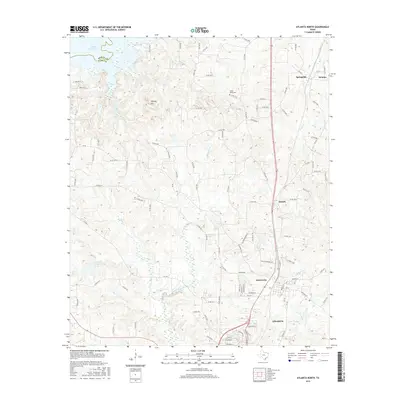
2016 Map of Atlanta North
USGS Topo · Published 2016About this map
Atlanta and Queen City serve as the primary hubs in this corner of Cass County, where the transition from organized municipal grids to the rolling timberlands of East Texas is clearly defined. The landscape is dominated by the intricate drainage systems of Black Bayou and Wilkins Cr, which flow toward the expansive Wright Patman Lake in the northwest. This 2016 survey illustrates the modern road network, including the heavily traveled corridors through Lanark and Springdale, while maintaining references to local heritage sites like Forest Home Cem. The proximity of the Bowie County line and the presence of industrial or railway-adjacent settlements like Domino reveal a region shaped by both its natural hydrology and its position as a crossroads for transport and commerce.
Find a feature on this map
102 named features on this map. Tap any name to fly to it.
Don’t see what you’re looking for? This feature index may not catch every label — zoom into the map to look around manually.
Map Details
Editions of this 2016 Atlanta North Map
This is the sole edition of this map. No revisions or reprints were ever made.
Other maps of this area

1907 · Atlanta
USGS Topo · 1:62,500

1909 · New Boston
USGS Topo · 1:62,500

1909 · Texarkana
USGS Topo · 1:62,500

1910 · Linden
USGS Topo · 1:62,500

1910 · Atlanta
USGS Topo · 1:62,500

1953 · Texarkana
USGS Topo · 1:250,000

1954 · Domino
USGS Topo · 1:24,000

1954 · Lake Texarkana
USGS Topo · 1:24,000
1954 · Texarkana
USGS Topo · 1:62,500

1955 · Maud
USGS Topo · 1:24,000