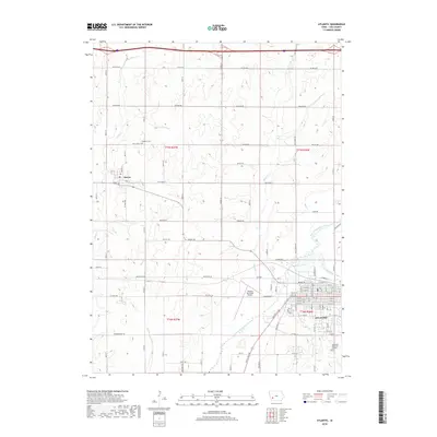
2018 Map of Atlantic
USGS Topo · Published 2018About this map
Atlantic and Marne anchor this Cass County landscape, revealing the modern spatial organization of southwestern Iowa's agricultural and transit corridors. The East Nishnabotna River winds through the southern portion of the quadrangle, joined by a network of local waterways including Buck Creek and Spring Creek. This 2018 survey captures the intersection of heavy infrastructure and local heritage, showing the Atlantic Municipal Airport alongside long-established sites like Brighton Cemetery and Southlawn Memorial Gardens. The map details an extensive grid of country roads such as Chicago Road, Dallas Road, and County Highway G30, which facilitate the region's movement of goods. From the northern reach of Camp Creek to the southeastern flow of Troublesome Creek, the terrain reflects a well-integrated system of small-town centers and the surrounding prairie-turned-farmland typical of the Nishnabotna valley.
Find a feature on this map
36 named features on this map. Tap any name to fly to it.
Don’t see what you’re looking for? This feature index may not catch every label — zoom into the map to look around manually.
Map Details
Editions of this 2018 Atlantic Map
This is the sole edition of this map. No revisions or reprints were ever made.
Other maps of this area

1954 · Omaha
USGS Topo · 1:250,000

1957 · Omaha
USGS Topo · 1:250,000

1957 · Audubon
USGS Topo · 1:62,500

1958 · Omaha
USGS Topo · 1:250,000

1971 · Walnut
USGS Topo · 1:24,000

1971 · Wiota
USGS Topo · 1:24,000

1971 · Atlantic
USGS Topo · 1:24,000

1971 · Atlantic SW
USGS Topo · 1:24,000

1971 · Anita SW
USGS Topo · 1:24,000

1971 · Lewis
USGS Topo · 1:24,000