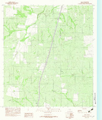
1982 Map of Atlee
USGS Topo · Published 1982About this map
The small settlement of Atlee serves as a quiet focal point in this south Texas landscape, situated along the vital transport corridor of the Missouri Pacific railroad. The terrain is defined by the ephemeral drainage patterns of Las Raices Creek, Caiman Creek, and Tecolote Creek, which carve through the brush country of La Salle County. A notable industrial presence is indicated by an Air Landing Strip and a network of Underground Pipe lines, suggesting the region's involvement in mid-century resource extraction or large-scale ranching operations. The mapping reflects a period when rural infrastructure was being precisely documented through aerial photography and field checks, capturing the relationship between the railway and the isolated outposts it once sustained.
Find a feature on this map
7 named features on this map. Tap any name to fly to it.
Don’t see what you’re looking for? This feature index may not catch every label — zoom into the map to look around manually.
Map Details
Editions of this 1982 Atlee Map
This is the sole edition of this map. No revisions or reprints were ever made.
Other maps of this area

1927 · Bart
USGS Topo · 1:62,500

1929 · Cotulla
USGS Topo · 1:125,000

1940 · Cotulla
USGS Topo · 1:62,500

1940 · Artesia Wells
USGS Topo · 1:62,500

1953 · Crystal City
USGS Topo · 1:250,000

1955 · Crystal City
USGS Topo · 1:250,000

1957 · Encinal
USGS Topo · 1:62,500

1957 · Caiman Creek
USGS Topo · 1:62,500

1961 · Crystal City
USGS Topo · 1:250,000

1968 · Crystal City
USGS Topo · 1:250,000