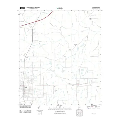
2011 Map of Atmore
USGS Topo · Published 2011About this map
Atmore serves as a central hub in this Southern Alabama landscape, where the intersection of roads and railways facilitates regional movement. The town is surrounded by a network of smaller established communities such as Robinsonville, Malta, and Little Rock. The land is defined by the drainages of Canoe Creek, Brushy Creek, and Sizemore Creek, which carve through the terrain between pockets of industrial activity. To the northeast, the Little Rock Gas Field and Big Escambia Creek Gas Field indicate the importance of energy extraction to the local economy. The map also documents numerous community landmarks, including Serenity Garden Cemetery and the Atmore Municipal Airport, alongside several smaller rural burial grounds like Canoe Cemetery and Lucy Hill Cemetery. This documentation provides a clear picture of the rural and industrial balance in Escambia County at the start of the 2010s.
Find a feature on this map
120 named features on this map. Tap any name to fly to it.
Don’t see what you’re looking for? This feature index may not catch every label — zoom into the map to look around manually.
Map Details
Editions of this 2011 Atmore Map
This is the sole edition of this map. No revisions or reprints were ever made.
Other maps of this area

1941 · Century
USGS Topo · 1:62,500

1942 · Perdido
USGS Topo · 1:62,500

1942 · Dyas
USGS Topo · 1:62,500

1943 · Century
USGS Topo · 1:62,500

1944 · Dyas
USGS Topo · 1:62,500

1944 · Perdido
USGS Topo · 1:62,500

1953 · Andalusia
USGS Topo · 1:250,000

1957 · Andalusia
USGS Topo · 1:250,000

1957 · Pensacola
USGS Topo · 1:250,000

1959 · Pensacola
USGS Topo · 1:250,000