
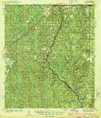
1944 Map of Dyas
USGS Topo · Published 1944About this map
The Perdido River serves as a winding natural boundary between Alabama and Florida in this 1940s survey of the borderlands. The landscape is defined by the St Stephens Base Line, a critical surveying meridian that runs through the northern portion of the map, influencing the rigid grid of land ownership and road placement. Small settlements like Dyas and Carney sit along the route of the Louisville and Nashville Railroad, which provided essential transportation for the region's timber and agricultural interests.
Find a feature on this map
52 named features on this map. Tap any name to fly to it.
Don’t see what you’re looking for? This feature index may not catch every label — zoom into the map to look around manually.
Map Details
Editions of this 1944 Dyas Map
2 editions found
Other maps of this area

1920 · Robertsdale
USGS Topo · 1:62,500

1921 · Fairhope
USGS Topo · 1:62,500

1921 · Muscogee
USGS Topo · 1:62,500

1941 · Bay Minette
USGS Topo · 1:62,500

1941 · Muscogee
USGS Topo · 1:62,500

1941 · Robertsdale
USGS Topo · 1:62,500

1941 · Century
USGS Topo · 1:62,500

1941 · Fairhope
USGS Topo · 1:62,500

1942 · Perdido
USGS Topo · 1:62,500

1942 · Dyas
USGS Topo · 1:62,500