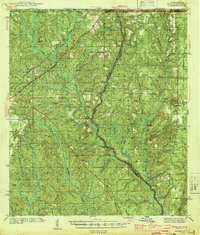
1944 Map of Dyas
USGS Topo · Published 1944About this map
The Perdido River and the winding Styx River define this rural landscape along the Alabama-Florida border during the early 1940s. The region is marked by small settlements and family hubs like Walnut Hill and Phillipsville, connected by the Louisville and Nashville and St Louis San Francisco railroads. This era's infrastructure is dominated by timber and forest management, evidenced by the Walnut Hill Fire Tower and the Bingham Fire Tower. Local community life centers on country landmarks such as New Providence Ch, Antioch Ch, and the Dry Springs Ch. Significant surveying points like the Base Line and the Airway Beacon near Dyas indicate the growing importance of regional navigation. The numerous creeks, such as McCurtin Creek and Horseneck Creek, carve through the terrain, illustrating the natural drainage patterns that shaped early settlement and road placement in Baldwin and Escambia counties.
Find a feature on this map
53 named features on this map. Tap any name to fly to it.
Don’t see what you’re looking for? This feature index may not catch every label — zoom into the map to look around manually.
Map Details
Editions of this 1944 Dyas Map
2 editions found

Other maps of this area

1920 · Robertsdale
USGS Topo · 1:62,500

1921 · Fairhope
USGS Topo · 1:62,500

1921 · Muscogee
USGS Topo · 1:62,500

1941 · Bay Minette
USGS Topo · 1:62,500

1941 · Muscogee
USGS Topo · 1:62,500

1941 · Robertsdale
USGS Topo · 1:62,500

1941 · Century
USGS Topo · 1:62,500

1941 · Fairhope
USGS Topo · 1:62,500

1942 · Perdido
USGS Topo · 1:62,500

1942 · Dyas
USGS Topo · 1:62,500