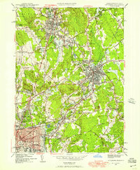
1949 Map of Attleboro
USGS Topo · Published 1957About this map
The industrial and civic centers of North Attleboro and Attleboro anchor this 1949 revision, showing the dense network of streets and institutions that defined the borderlands of Massachusetts and Rhode Island. The New York New Haven and Hartford RR serves as a central artery for the region, connecting the urban core to peripheral settlements like Dodgeville, Hebronville, and Perrins Crossing. Religious and educational sites are numerous, including St Marys Ch, the La Sallette Seminary, and local schoolhouses such as the Adamsdale Sch and Lincoln Sch.
Find a feature on this map
105 named features on this map. Tap any name to fly to it.
Don’t see what you’re looking for? This feature index may not catch every label — zoom into the map to look around manually.
Map Details
Editions of this 1949 Attleboro Map
This is the sole edition of this map. No revisions or reprints were ever made.
Other maps of this area

1885 · Taunton
USGS Topo · 1:62,500

1886 · Dedham
USGS Topo · 1:62,500

1887 · Franklin
USGS Topo · 1:62,500

1887 · Providence
USGS Topo · 1:62,500

1888 · Taunton
USGS Topo · 1:62,500

1889 · Providence
USGS Topo · 1:62,500

1889 · Franklin
USGS Topo · 1:62,500

1893 · Taunton
USGS Topo · 1:62,500

1893 · Franklin
USGS Topo · 1:62,500

1894 · Dedham
USGS Topo · 1:62,500