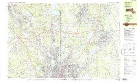
1987 Map of Attleboro
USGS Topo · Published 1987About this map
The Blackstone River corridor anchors this late-twentieth-century study of the Rhode Island and Massachusetts borderlands, revealing a landscape defined by industrial legacy and suburban transition. The historic Blackstone Canal remains a visible thread through the valley, passing through established mill settlements like Saylesville and Valley Falls. These dense urban clusters in the south contrast with the recreational and residential expansion toward North Attleborough and the northern highlands.
Find a feature on this map
124 named features on this map. Tap any name to fly to it.
Don’t see what you’re looking for? This feature index may not catch every label — zoom into the map to look around manually.
Map Details
Editions of this 1987 Attleboro Map
2 editions found
Other maps of this area

1885 · Taunton
USGS Topo · 1:62,500

1886 · Blackstone
USGS Topo · 1:62,500

1886 · Dedham
USGS Topo · 1:62,500

1887 · Franklin
USGS Topo · 1:62,500

1887 · Providence
USGS Topo · 1:62,500

1888 · Taunton
USGS Topo · 1:62,500

1889 · Providence
USGS Topo · 1:62,500

1889 · Blackstone
USGS Topo · 1:62,500

1889 · Franklin
USGS Topo · 1:62,500

1889 · Burrillville
USGS Topo · 1:62,500