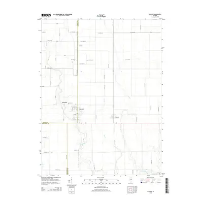
2015 Map of Atwood
USGS Topo · Published 2015About this map
Atwood and Garrett serve as the primary hubs of this agricultural landscape in central Illinois, where the borders of Piatt, Douglas, and Moultrie counties converge. The drainage patterns of the Kaskaskia River and its tributaries, including Lake Fork, Dry Fork, and Bear Cr, define the topography and have historically influenced the placement of roads and farmsteads. This map reveals a high density of small family or community burial grounds, such as Antioch Cem, Mackville Cem, and Taylor Cem, which offer significant value for genealogists tracing early settlement patterns in the region. The inclusion of the Cooch Landing Area along with the grid-based road system, featuring named routes like N Main St and Hickory Ave in the larger towns, provides a clear view of the rural infrastructure as it stood in the mid-2010s.
Find a feature on this map
67 named features on this map. Tap any name to fly to it.
Don’t see what you’re looking for? This feature index may not catch every label — zoom into the map to look around manually.
Map Details
Editions of this 2015 Atwood Map
This is the sole edition of this map. No revisions or reprints were ever made.
Other maps of this area

1935 · Arcola
USGS Topo · 1:48,000

1935 · Sullivan
USGS Topo · 1:48,000

1940 · Sullivan
USGS Topo · 1:62,500

1940 · Arcola
USGS Topo · 1:62,500

1950 · Tuscola
USGS Topo · 1:62,500

1955 · Bement
USGS Topo · 1:62,500

1958 · Decatur
USGS Topo · 1:250,000

1961 · Decatur
USGS Topo · 1:250,000
1975 · Tuscola NE
USGS Topo · 1:24,000
1975 · Tuscola NW
USGS Topo · 1:24,000