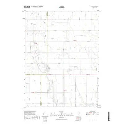
2018 Map of Atwood
USGS Topo · Published 2018About this map
Atwood and Garrett anchor this landscape at the intersection of Douglas, Piatt, and Moultrie counties, reflecting the deep agricultural roots of central Illinois. The survey detail highlights a dense network of country roads and county lines, such as Co HWY 14 and Co RD 950 N, that organize the prairie into a distinct grid. Waterways like the Kaskaskia River in the southeast and the winding Lake Fork determine the drainage patterns across the flat terrain, while smaller tributaries including Bear Cr and Dry Fork carve subtle paths through the fields. For those tracing family histories, the map preserves the locations of several rural burying grounds, including Antioch Cem, Moore Cem, and the Lake Fork Cem. Small settlements like Mackville further illustrate the distribution of late-century population centers that grew alongside the regional road and rail network.
Find a feature on this map
82 named features on this map. Tap any name to fly to it.
Don’t see what you’re looking for? This feature index may not catch every label — zoom into the map to look around manually.
Map Details
Editions of this 2018 Atwood Map
This is the sole edition of this map. No revisions or reprints were ever made.
Other maps of this area

1935 · Arcola
USGS Topo · 1:48,000

1935 · Sullivan
USGS Topo · 1:48,000

1940 · Sullivan
USGS Topo · 1:62,500

1940 · Arcola
USGS Topo · 1:62,500

1950 · Tuscola
USGS Topo · 1:62,500

1955 · Bement
USGS Topo · 1:62,500

1958 · Decatur
USGS Topo · 1:250,000

1961 · Decatur
USGS Topo · 1:250,000
1975 · Tuscola NE
USGS Topo · 1:24,000
1975 · Tuscola NW
USGS Topo · 1:24,000