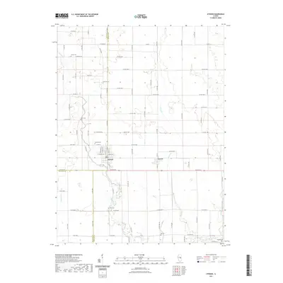
2021 Map of Atwood
USGS Topo · Published 2021About this map
Atwood and Garrett serve as the primary hubs in this agricultural landscape straddling the borders of Piatt, Douglas, and Moultrie counties. The terrain is defined by a series of north-south drainage systems, including Lake Fork, Bear Cr, and Dry Fork, which feed toward the Kaskaskia River in the southeastern corner. This drainage network influenced the placement of early settlements and the long-established burial grounds that dot the countryside. Genealogists will find a high concentration of small, family-named cemeteries such as Antioch Cem, Lake Fork Cem, Moore Cem, and Mackville Cem located along these waterways and rural section lines. The map reveals the rigid grid of county roads, like Co HWY 14 and E Co RD 1100n, which intersect the natural curves of Neutral Ditch and other stream beds, illustrating the persistent intersection of Illinois prairie farming with the regional hydrology.
Find a feature on this map
83 named features on this map. Tap any name to fly to it.
Don’t see what you’re looking for? This feature index may not catch every label — zoom into the map to look around manually.
Map Details
Editions of this 2021 Atwood Map
This is the sole edition of this map. No revisions or reprints were ever made.
Other maps of this area

1935 · Arcola
USGS Topo · 1:48,000

1935 · Sullivan
USGS Topo · 1:48,000

1940 · Sullivan
USGS Topo · 1:62,500

1940 · Arcola
USGS Topo · 1:62,500

1950 · Tuscola
USGS Topo · 1:62,500

1955 · Bement
USGS Topo · 1:62,500

1958 · Decatur
USGS Topo · 1:250,000

1961 · Decatur
USGS Topo · 1:250,000
1975 · Tuscola NE
USGS Topo · 1:24,000
1975 · Tuscola NW
USGS Topo · 1:24,000