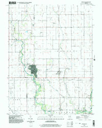
1998 Map of Atwood
USGS Topo · Published 2003About this map
Atwood straddles the boundary of Piatt Co and Douglas Co in this detailed 1990s study of the Illinois prairie. The landscape is defined by the headwaters of the Kaskaskia River and its tributaries, including Lake Fork, Dry Fork, and Bear Creek. These waterways dictate the placement of early community landmarks, such as the Mackville Cem and Richey Park near the town center. The rural areas surrounding the main settlement are dotted with family-named locations and small airstrips like the Bragg Landing Strip and Cooch Landing Strip, reflecting the region's agricultural and private aviation history.
Find a feature on this map
36 named features on this map. Tap any name to fly to it.
Don’t see what you’re looking for? This feature index may not catch every label — zoom into the map to look around manually.
Map Details
Editions of this 1998 Atwood Map
This is the sole edition of this map. No revisions or reprints were ever made.
Other maps of this area

1935 · Arcola
USGS Topo · 1:48,000

1935 · Sullivan
USGS Topo · 1:48,000

1940 · Sullivan
USGS Topo · 1:62,500

1940 · Arcola
USGS Topo · 1:62,500

1950 · Tuscola
USGS Topo · 1:62,500

1955 · Bement
USGS Topo · 1:62,500

1958 · Decatur
USGS Topo · 1:250,000

1961 · Decatur
USGS Topo · 1:250,000
1975 · Tuscola NE
USGS Topo · 1:24,000
1975 · Tuscola NW
USGS Topo · 1:24,000