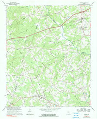
1964 Map of Auburn
USGS Topo · Published 1990About this map
The Seaboard Air Line railroad corridor anchors the southern portion of this landscape, connecting the neighboring communities of Auburn and Carl. This mid-century survey reveals a transition between rural agriculture and the early infrastructure of the interstate era, notably where several county lines converge. Waterways like the Mulberry River and the Apalachee River define the local topography, with a historic Covered Bridge and Thompsons Mill serving as landmarks of an earlier industrial period. The map is densely populated with community centers, including County High Sch in Braselton and numerous rural houses of worship such as New Liberty Ch and Harmony Grove Ch. Family names are deeply etched into the local geography through an extensive network of secondary roads like Flanagan Mill Road and Bramlett Rd, which trace the established property lines and agricultural boundaries of the time.
Find a feature on this map
71 named features on this map. Tap any name to fly to it.
Don’t see what you’re looking for? This feature index may not catch every label — zoom into the map to look around manually.
Map Details
Editions of this 1964 Auburn Map
3 editions found
Other maps of this area

1891 · Gainesville
USGS Topo · 1:125,000

1896 · Monroe
USGS Topo · 1:125,000

1953 · Athens
USGS Topo · 1:250,000

1954 · Greenville
USGS Topo · 1:250,000

1958 · Greenville
USGS Topo · 1:250,000

1958 · Athens
USGS Topo · 1:250,000

1959 · Athens
USGS Topo · 1:250,000

1963 · Athens
USGS Topo · 1:250,000

1964 · Hog Mountain
USGS Topo · 1:24,000

1964 · Chestnut Mountain
USGS Topo · 1:24,000