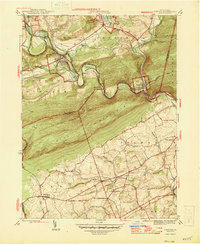
1946 Map of Auburn
USGS Topo · Published 1946About this map
The Schuylkill River carves a deep, winding path through the gap in Blue Mountain, serving as a historic transportation corridor for the Pennsylvania RR and the Reading line. This 1945 survey captures the industrial and agricultural landscape of the Schuylkill and Berks county line just after the war. In the north, the river meanders past Auburn and Port Clinton, while the southern slopes are dotted with rural infrastructure like St Michaels Ch and Salem Ch. The ridge line is defined by the Appalachian Trail, which follows the high ground above the Auburn Res. Numerous small local schools, including Tunnel Sch, Mangel Sch, and Jefferson Sch, indicate the decentralized educational network of the mid-20th century before the era of district consolidation, while settlements like Jalappa and Shartlesville anchor the surrounding valley farms.
Find a feature on this map
41 named features on this map. Tap any name to fly to it.
Don’t see what you’re looking for? This feature index may not catch every label — zoom into the map to look around manually.
Map Details
Editions of this 1946 Auburn Map
2 editions found
Other maps of this area

1889 · Pottsville
USGS Topo · 1:62,500

1891 · Pottsville
USGS Topo · 1:62,500

1894 · Reading
USGS Topo · 1:62,500

1902 · Wernersville
USGS Topo · 1:62,500

1909 · Hamburg
USGS Topo · 1:62,500

1911 · Hamburg
USGS Topo · 1:62,500

1913 · Reading
USGS Topo · 1:62,500

1915 · Reading
USGS Topo · 1:62,500

1943 · Wernersville
USGS Topo · 1:62,500

1944 · Reading
USGS Topo · 1:62,500