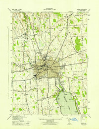
1943 Map of Auburn
USGS Topo · Published 1943About this map
Auburn serves as the industrial and civic anchor of this 1943 survey, centered on the complex of the Auburn State Prison and the busy municipal core near City Hall. The landscape is defined by the Owasco Outlet flowing north from Owasco Lake, powering a corridor of development that includes the Pumping Station and several gaging points. To the west and north, the terrain transitions into a grid of rural school districts and small crossroads like Half Acre and McMaster Corners.
Find a feature on this map
59 named features on this map. Tap any name to fly to it.
Don’t see what you’re looking for? This feature index may not catch every label — zoom into the map to look around manually.
Map Details
Editions of this 1943 Auburn Map
This is the sole edition of this map. No revisions or reprints were ever made.
Other maps of this area

1899 · Auburn
USGS Topo · 1:62,500

1899 · Skaneateles
USGS Topo · 1:62,500

1900 · Baldwinsville
USGS Topo · 1:62,500

1902 · Skaneateles
USGS Topo · 1:62,500

1902 · Weedsport
USGS Topo · 1:62,500

1902 · Auburn
USGS Topo · 1:62,500

1943 · Jordan
USGS Topo · 1:31,680

1943 · Montezuma
USGS Topo · 1:31,680

1943 · Cayuga
USGS Topo · 1:31,680

1943 · Owasco
USGS Topo · 1:31,680