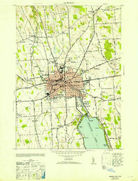
1953 Map of Auburn
USGS Topo · Published 1953About this map
Auburn functions as a bustling regional hub in the mid-1950s, its urban core dominated by the Auburn State Prison and an extensive grid of streets including Genesee St and Franklin Street. The Owasco Outlet snakes north from the northern tip of Owasco Lake, passing the city's Gaging Station and Disposal Plant as it flows toward Throopsville. This era captures the city's industrial and institutional footprint, from the State Prison Farm in the east to the Airport in the northwest. Surrounding the city, the landscape is dotted with smaller settlements like Half Acre and Sennett, while the lakefront at Highland Beach and Poplar Cove suggests the area's recreational appeal. The rail network remains vital, with the Lehigh Valley and New York Central lines facilitating movement through the county.
Find a feature on this map
61 named features on this map. Tap any name to fly to it.
Don’t see what you’re looking for? This feature index may not catch every label — zoom into the map to look around manually.
Map Details
Editions of this 1953 Auburn Map
This is the sole edition of this map. No revisions or reprints were ever made.
Other maps of this area

1899 · Auburn
USGS Topo · 1:62,500

1899 · Skaneateles
USGS Topo · 1:62,500

1900 · Baldwinsville
USGS Topo · 1:62,500

1902 · Skaneateles
USGS Topo · 1:62,500

1902 · Weedsport
USGS Topo · 1:62,500

1902 · Auburn
USGS Topo · 1:62,500

1943 · Jordan
USGS Topo · 1:31,680

1943 · Montezuma
USGS Topo · 1:31,680

1943 · Cayuga
USGS Topo · 1:31,680

1943 · Owasco
USGS Topo · 1:31,680