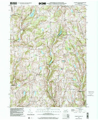
1999 Map of Auburn Center
USGS Topo · Published 2001About this map
Auburn Center serves as a central point in this rural landscape where the boundaries of Susquehanna, Wyoming, and Bradford counties converge. The terrain is defined by the winding paths of Tuscarora Creek and Little Meshoppen Creek, which carve through a series of highlands marked by named summits like Round Top. This late-twentieth-century survey documents a persistent pattern of small, family-named crossroads settlements such as Carter Corners, Angie Corners, and Chase Corners. Genealogy researchers will find significant value in the distribution of local landmarks, including the Boles Cem and several community anchors like Jersey Hill Ch and St Bonaventure Ch. The presence of numerous upland water bodies, including White Pond and Carlin Pond, illustrates the drainage patterns that have shaped agricultural and residential development in these hills for generations.
Find a feature on this map
38 named features on this map. Tap any name to fly to it.
Don’t see what you’re looking for? This feature index may not catch every label — zoom into the map to look around manually.
Map Details
Editions of this 1999 Auburn Center Map
This is the sole edition of this map. No revisions or reprints were ever made.
Other maps of this area

1943 · Montrose
USGS Topo · 1:62,500

1943 · Le Raysville
USGS Topo · 1:62,500

1945 · Montrose
USGS Topo · 1:62,500

1945 · Le Raysville
USGS Topo · 1:62,500

1945 · Meshoppen
USGS Topo · 1:62,500

1945 · Auburn Center
USGS Topo · 1:24,000

1945 · Jenningsville
USGS Topo · 1:24,000

1945 · Meshoppen
USGS Topo · 1:24,000

1945 · Laceyville
USGS Topo · 1:24,000

1946 · Tunkhannock
USGS Topo · 1:62,500
Featured Places
- Rush Township, PA
- Scranton Corners, Meshoppen Township
- Auburn Center, PA
- Stevens Township, PA
- Tuscarora Township, PA