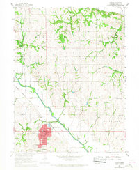
1966 Map of Auburn
USGS Topo · Published 1968About this map
Auburn serves as the focal point of this mid-1960s study, situated where the Missouri Pacific railroad intersects the fertile valley of the Little Nemaha River. The town's grid is dense with civic infrastructure, including the Courthouse, County Hospital, and County Fairground, alongside several educational landmarks like Sheridan Sch and the Calvert Sch. The surrounding landscape is defined by its agricultural character and the complex drainage of waterways like Honey Creek, Willow Creek, and Duck Creek.
Find a feature on this map
34 named features on this map. Tap any name to fly to it.
Don’t see what you’re looking for? This feature index may not catch every label — zoom into the map to look around manually.
Map Details
Editions of this 1966 Auburn Map
This is the sole edition of this map. No revisions or reprints were ever made.
Other maps of this area

1907 · Nebraska City
USGS Topo · 1:62,500

1915 · Nemaha
USGS Topo · 1:62,500

1915 · Howe
USGS Topo · 1:62,500

1939 · Hamburg
USGS Topo · 1:62,500

1939 · Nemaha
USGS Topo · 1:62,500

1941 · Hamburg
USGS Topo · 1:62,500

1949 · Nemaha
USGS Topo · 1:62,500

1955 · Nebraska City
USGS Topo · 1:250,000

1957 · Nebraska City
USGS Topo · 1:250,000

1958 · Nebraska City
USGS Topo · 1:250,000
Featured Places
- Auburn, NE
- Terrace Mobile Home Park, Auburn
- Southside Trailer Park, Auburn
- Nemaha County, NE
- United States