
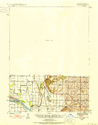
1939 Map of Hamburg
USGS Topo · Published 1939About this map
McKissock Island sits at the heart of a complex border region where the shifting courses of the Missouri River and Nishnabotna River define the intersections of Iowa, Missouri, and Nebraska. Surveyed in 1939 by K. D. Cox and C. L. Stites, the map documents a landscape of fertile bottomlands and intricate water features like Lewis Slough and Holly Slough. The rural social fabric of the era is remarkably dense, evidenced by a high concentration of country schools such as Lewis Sch, Island Sch, and Tiny Sch, alongside community landmarks like Cox Chapel. The eastern portion of the quadrangle rises into more varied terrain drained by High Creek and McElroy Creek, where the Chicago Burlington and Quincy railroad tracks provide a vital transport link through the river valley near Greys Lake.
Find a feature on this map
35 named features on this map. Tap any name to fly to it.
Don’t see what you’re looking for? This feature index may not catch every label — zoom into the map to look around manually.
Map Details
Editions of this 1939 Hamburg Map
2 editions found
Other maps of this area

1907 · Nebraska City
USGS Topo · 1:62,500

1915 · Nemaha
USGS Topo · 1:62,500

1915 · Howe
USGS Topo · 1:62,500

1935 · Nehawka
USGS Topo · 1:48,000

1939 · Tarkio
USGS Topo · 1:62,500

1939 · Farragut
USGS Topo · 1:62,500

1939 · Nemaha
USGS Topo · 1:62,500

1940 · Tarkio
USGS Topo · 1:62,500

1940 · Farragut
USGS Topo · 1:62,500

1940 · Nehawka
USGS Topo · 1:62,500