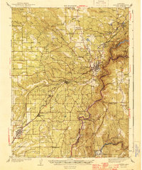
1944 Map of Auburn
USGS Topo · Published 1944About this map
Auburn serves as the focal point of this 1940s survey, where the Southern Pacific railroad threads through the foothills connecting Bowman, Newcastle, Loomis, and Rocklin. The landscape is defined by the deep canyons of the North Fork American River and the South Fork American River, meeting at the border of Placer and El Dorado counties. Numerous rural schoolhouses, including the Japanese Sch and Gold Hill Sch, suggest a dispersed but established agricultural community. Traces of early river infrastructure and mining-era geography are visible at Rattlesnake Bridge, Horseshoe Bar, and Oregon Bar, while the presence of the Auburn Airport and multiple Airway Beacons marks the modernization of transport in the years following the Great Depression.
Find a feature on this map
64 named features on this map. Tap any name to fly to it.
Don’t see what you’re looking for? This feature index may not catch every label — zoom into the map to look around manually.
Map Details
Editions of this 1944 Auburn Map
3 editions found
Other maps of this area

1888 · Smartsville
USGS Topo · 1:125,000

1891 · Sacramento
USGS Topo · 1:125,000

1891 · Colfax
USGS Topo · 1:125,000

1891 · Smartsville
USGS Topo · 1:125,000

1891 · Placerville
USGS Topo · 1:125,000

1892 · Sacramento
USGS Topo · 1:125,000

1892 · Placerville
USGS Topo · 1:125,000

1892 · Smartsville
USGS Topo · 1:125,000

1892 · Colfax
USGS Topo · 1:125,000

1893 · Placerville
USGS Topo · 1:125,000