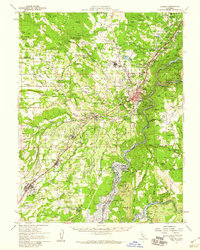
1954 Map of Auburn
USGS Topo · Published 1959About this map
Gold mining history is etched into the landscape surrounding Auburn and the North Fork American River. Numerous placer sites like Mammoth Bar, New York Bar, and Murderers Bar line the river canyons, while the lower elevations near Loomis and Rocklin are marked by extensive Dredge Tailings. The mid-1950s geography shows the impending transformation of the river valleys by the Folsom Reservoir, with blue hatching indicating areas destined to be submerged, including the Salmon Falls settlement and Whiskey Bar. Cultural landmarks such as the DeWitt State Hospital and Auburn Rancheria sit alongside the busy Southern Pacific rail line and U.S. 40, illustrating the region's role as a major transportation corridor through the Sierra Nevada foothills.
Find a feature on this map
97 named features on this map. Tap any name to fly to it.
Don’t see what you’re looking for? This feature index may not catch every label — zoom into the map to look around manually.
Map Details
Editions of this 1954 Auburn Map
2 editions found
Other maps of this area

1888 · Smartsville
USGS Topo · 1:125,000

1891 · Sacramento
USGS Topo · 1:125,000

1891 · Colfax
USGS Topo · 1:125,000

1891 · Smartsville
USGS Topo · 1:125,000

1891 · Placerville
USGS Topo · 1:125,000

1892 · Sacramento
USGS Topo · 1:125,000

1892 · Placerville
USGS Topo · 1:125,000

1892 · Smartsville
USGS Topo · 1:125,000

1892 · Colfax
USGS Topo · 1:125,000

1893 · Placerville
USGS Topo · 1:125,000