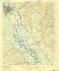
1921 Map of Augusta
USGS Topo · Published 1943About this map
The Savannah River defines this landscape as it meanders between Georgia and South Carolina, its course marked by numerous oxbows and relic channels such as Horseshoe Lake and Island Lake. In the northwest, the city of Augusta and its neighbor North Augusta are shown with their dense street grids and established rail infrastructure, including the Southern RR and Georgia RR. The surrounding countryside is dotted with rural institutions that serve as vital genealogical markers, from the Spiderweb School and Freetown School to the Beech Island Church.
Find a feature on this map
97 named features on this map. Tap any name to fly to it.
Don’t see what you’re looking for? This feature index may not catch every label — zoom into the map to look around manually.
Map Details
Editions of this 1921 Augusta Map
5 editions found
Other maps of this area

1892 · Mc Cormick
USGS Topo · 1:125,000

1912 · Mc Cormick
USGS Topo · 1:125,000

1919 · Gough
USGS Topo · 1:62,500

1920 · Ellenton
USGS Topo · 1:48,000

1920 · Greens Cut
USGS Topo · 1:62,500

1920 · Aiken
USGS Topo · 1:48,000

1920 · Talatha
USGS Topo · 1:48,000

1920 · Clarks Hill
USGS Topo · 1:48,000

1921 · Augusta
USGS Topo · 1:62,500

1921 · Aiken
USGS Topo · 1:62,500