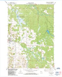
1984 Map of Augusta East
USGS Topo · Published 1984About this map
Augusta serves as the primary hub in this mid-1980s landscape, where the Eau Claire River meanders through the northern reaches near Whippoorwill Creek. The area is defined by a blend of conservation and recreation, most notably the expansive Augusta State Wildlife Area and the Coon Fork County Park surrounding Coon Fork Lake. A distinctive agricultural and industrial footprint is visible through the presence of a Cranberry Bog and numerous gravel and shale pits scattered across the township.
Find a feature on this map
38 named features on this map. Tap any name to fly to it.
Don’t see what you’re looking for? This feature index may not catch every label — zoom into the map to look around manually.
Map Details
Editions of this 1984 Augusta East Map
This is the sole edition of this map. No revisions or reprints were ever made.
Other maps of this area

1935 · Osseo
USGS Topo · 1:48,000

1940 · Osseo
USGS Topo · 1:62,500

1948 · Fairchild
USGS Topo · 1:62,500

1949 · Fairchild
USGS Topo · 1:62,500

1952 · Cadott
USGS Topo · 1:62,500

1952 · Stanley
USGS Topo · 1:62,500

1953 · Eau Claire
USGS Topo · 1:250,000

1958 · Eau Claire
USGS Topo · 1:250,000

1964 · Eau Claire
USGS Topo · 1:250,000
1968 · Osseo
USGS Topo · 1:62,500