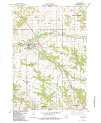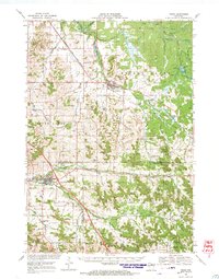
1968 Map of Osseo
USGS Topo · Published 1971About this map
The Chicago and North Western railroad forms a dominant diagonal through this late 1960s landscape, connecting the agricultural communities of Augusta and Osseo. The terrain is defined by the complex drainage systems of the Claire River and the North Fork Buffalo River, with numerous small valleys like Thompson Valley and Diamond Valley Creek providing fertile ground for settlement. Genealogists will find several rural landmarks of interest, including the South Beef River Ch and the Lincoln Cem, alongside scattered schools labeled simply as Townhall.
Find a feature on this map
76 named features on this map. Tap any name to fly to it.
Don’t see what you’re looking for? This feature index may not catch every label — zoom into the map to look around manually.
Map Details
Editions of this 1968 Osseo Map
This is the sole edition of this map. No revisions or reprints were ever made.
Historical Maps of Osseo Through Time
5 maps found