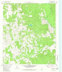
1982 Map of Augusta
USGS Topo · Published 1982About this map
The Davy Crockett National Forest dominates the eastern half of this landscape, where the Neches River forms the natural boundary between Houston, Anderson, and Cherokee counties. This 1982 edition captures the rural character of East Texas, centered on the historic crossroads of Augusta and the nearby settlements of Liberty Hill and Waneta. The terrain is defined by a dense network of drainage systems, including Miles Creek, Silver Creek, and San Pedro Creek, which carve through the wooded uplands near Franklin Top.
Find a feature on this map
32 named features on this map. Tap any name to fly to it.
Don’t see what you’re looking for? This feature index may not catch every label — zoom into the map to look around manually.
Map Details
Editions of this 1982 Augusta Map
This is the sole edition of this map. No revisions or reprints were ever made.
Other maps of this area

1946 · Alto
USGS Topo · 1:62,500

1950 · Crockett NE
USGS Topo · 1:24,000

1950 · Ratcliff
USGS Topo · 1:24,000

1951 · Grapeland
USGS Topo · 1:24,000

1951 · Crockett NE
USGS Topo · 1:24,000

1951 · Ratcliff
USGS Topo · 1:24,000

1952 · Slocum
USGS Topo · 1:62,500

1953 · Palestine
USGS Topo · 1:250,000

1957 · Palestine
USGS Topo · 1:250,000
1973 · Pryor Mountain
USGS Topo · 1:24,000