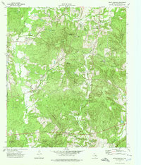
1973 Map of Pryor Mountain
USGS Topo · Published 1976About this map
Pryor Mountain and its surrounding peaks dominate this Cherokee County landscape, characterized by a complex network of high ridges and narrow creek valleys. In the early 1970s, this area remained largely rural, defined by small settlements like Bulah and Lone Oak. The map reveals a deeply rooted community structure through its numerous country churches and family burial grounds, including Adams Chapel, Lynchs Chapel, and Parker Lake Nelson Cem. The local economy is represented by the William Wise Oil Field and scattered gravel pits, while the terrain is carved by uniquely named waterways such as One Eye Creek and Black Eye Creek. From the heights of Reagan Mountain to the lowlands along Bowles Creek, the sheet provides an intricate look at East Texas topography and land use before extensive modern development altered these small upland communities.
Find a feature on this map
52 named features on this map. Tap any name to fly to it.
Don’t see what you’re looking for? This feature index may not catch every label — zoom into the map to look around manually.
Map Details
Editions of this 1973 Pryor Mountain Map
This is the sole edition of this map. No revisions or reprints were ever made.
Other maps of this area

1943 · Rusk
USGS Topo · 1:62,500

1945 · Rusk
USGS Topo · 1:62,500

1946 · Alto
USGS Topo · 1:62,500

1951 · Jacksonville
USGS Topo · 1:62,500

1952 · Slocum
USGS Topo · 1:62,500

1953 · Palestine
USGS Topo · 1:250,000

1957 · Palestine
USGS Topo · 1:250,000
1973 · Atoy
USGS Topo · 1:24,000
1973 · Forest
USGS Topo · 1:24,000
1973 · Alto
USGS Topo · 1:24,000