
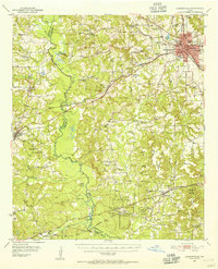
1951 Map of Jacksonville
USGS Topo · Published 1952About this map
Jacksonville serves as the bustling rail and educational hub of Cherokee County at the start of the 1950s. The city is defined by its strategic position at the intersection of three major railroads: the Missouri Pacific, the Southern Pacific, and the St Louis Southwestern. This transportation network supported institutions like Lon Morris College and Jacksonville College, as well as a local economy built on timber and agriculture. To the southwest, the Fairchild State Forest and the Neches River dominate the landscape, providing a sharp contrast to the industrial activities found at the Strip Mine and the Salt Evaporator near Clemons Sch. The map records a transition in rural life, visible in landmarks such as the Mt Hope Sch (Abandoned) and numerous country churches like Earls Chapel and Pierce Chapel.
Find a feature on this map
103 named features on this map. Tap any name to fly to it.
Don’t see what you’re looking for? This feature index may not catch every label — zoom into the map to look around manually.
Map Details
Editions of this 1951 Jacksonville Map
2 editions found
Other maps of this area

1937 · Troupe
USGS Topo · 1:48,000

1943 · Troup
USGS Topo · 1:62,500

1943 · Rusk
USGS Topo · 1:62,500

1945 · Rusk
USGS Topo · 1:62,500

1946 · Alto
USGS Topo · 1:62,500

1946 · Bullard
USGS Topo · 1:62,500

1948 · Bullard
USGS Topo · 1:62,500

1949 · Palestine
USGS Topo · 1:62,500

1949 · Frankston
USGS Topo · 1:62,500

1950 · Palestine
USGS Topo · 1:62,500