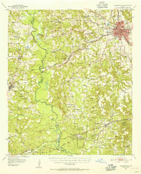
1951 Map of Jacksonville
USGS Topo · Published 1955About this map
Jacksonville serves as a major transportation and educational hub on this mid-century survey, where the Southern Pacific, St Louis Southwestern, and Missouri Pacific railroads converge. The city is noted for its academic institutions, including Lon Morris College and Jacksonville College. The surrounding landscape is a complex mix of agricultural land, timber, and oil exploration, evidenced by numerous pipe lines and a Strip Mine near Gray Mountain.
Find a feature on this map
89 named features on this map. Tap any name to fly to it.
Don’t see what you’re looking for? This feature index may not catch every label — zoom into the map to look around manually.
Map Details
Editions of this 1951 Jacksonville Map
2 editions found

Other maps of this area

1937 · Troupe
USGS Topo · 1:48,000

1943 · Troup
USGS Topo · 1:62,500

1943 · Rusk
USGS Topo · 1:62,500

1945 · Rusk
USGS Topo · 1:62,500

1946 · Alto
USGS Topo · 1:62,500

1946 · Bullard
USGS Topo · 1:62,500

1948 · Bullard
USGS Topo · 1:62,500

1949 · Palestine
USGS Topo · 1:62,500

1949 · Frankston
USGS Topo · 1:62,500

1950 · Palestine
USGS Topo · 1:62,500