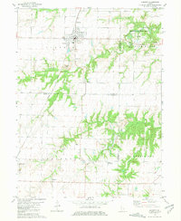
1981 Map of Augusta
USGS Topo · Published 1981About this map
The town of Augusta serves as the primary hub on this western Illinois landscape, situated at the intersection of local commerce and the Burlington Northern railroad line. The settlement character is defined by its organized grid, including a central High Sch and a local Fairground on the western edge. Beyond the town limits, the topography reveals a shift from agriculture to extraction, with distinct Strip Mined Areas scarring the terrain near Williams Creek.
Find a feature on this map
36 named features on this map. Tap any name to fly to it.
Don’t see what you’re looking for? This feature index may not catch every label — zoom into the map to look around manually.
Map Details
Editions of this 1981 Augusta Map
This is the sole edition of this map. No revisions or reprints were ever made.
Other maps of this area

1913 · Colchester
USGS Topo · 1:62,500

1933 · Carthage
USGS Topo · 1:62,500

1937 · Carthage
USGS Topo · 1:62,500

1946 · Augusta
USGS Topo · 1:62,500

1948 · Camp Point
USGS Topo · 1:62,500

1949 · Augusta
USGS Topo · 1:62,500

1958 · Burlington
USGS Topo · 1:250,000

1961 · Burlington
USGS Topo · 1:250,000

1963 · Burlington
USGS Topo · 1:250,000
1974 · Bentley
USGS Topo · 1:24,000