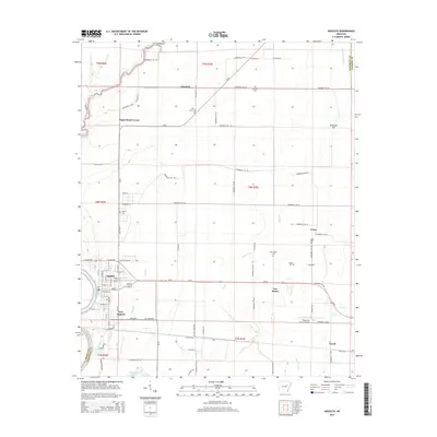
2014 Map of Augusta
USGS Topo · Published 2014About this map
Augusta and its neighbor New Augusta sit along the eastern bank of the White River, serving as the focal point for this Woodruff County landscape. The map reveals a transition from the river-fed wetlands of Taylor Bay and Horseshoe Lake to a grid of agricultural land defined by irrigation canals like Main Overcup Ditch and Maple Creek. Small rural communities and intersections such as Fitzhugh, Negro Head Corner, and Union are scattered across the interior, each anchored by local landmarks including Holly Grove Cem and Mt Olive Cem. The transportation network is built upon a combination of state routes like Ar-33 and a dense system of county roads, supporting the region's long-standing connection to the river and the fertile plains. The eastern edge of the quadrangle includes the Woodruff County Airport and the settlement of Cavell, illustrating the modern infrastructure of this traditional Delta landscape.
Find a feature on this map
73 named features on this map. Tap any name to fly to it.
Don’t see what you’re looking for? This feature index may not catch every label — zoom into the map to look around manually.
Map Details
Editions of this 2014 Augusta Map
This is the sole edition of this map. No revisions or reprints were ever made.
Other maps of this area

1935 · Augusta
USGS Topo · 1:62,500

1935 · Gregory
USGS Topo · 1:62,500

1939 · Hunter
USGS Topo · 1:62,500

1940 · Tilton
USGS Topo · 1:62,500

1953 · Memphis
USGS Topo · 1:250,000

1956 · Memphis
USGS Topo · 1:250,000

1956 · Tilton
USGS Topo · 1:62,500

1956 · Hunter
USGS Topo · 1:62,500

1957 · Augusta
USGS Topo · 1:62,500

1957 · Gregory
USGS Topo · 1:62,500