
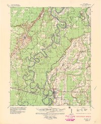
1935 Map of Augusta
USGS Topo · Published 1938About this map
The White River meanders through a landscape of oxbow lakes and timbered bottoms in this mid-1930s survey of the Arkansas Delta. The river’s shifting course is recorded in the numerous abandoned loops and cutoff bodies of water, including Big Jordan Lake, Walker Lake, and Big Horseshoe Lake. Transport and commerce are defined by the river and the Missouri Pacific railroad, which anchors the riverfront town of Augusta and its neighbor New Augusta. Several family-named landings and ferries, such as Robertson Ferry and Goad Ferry, indicate how residents crossed the water before widespread bridging.
Find a feature on this map
87 named features on this map. Tap any name to fly to it.
Don’t see what you’re looking for? This feature index may not catch every label — zoom into the map to look around manually.
Map Details
Editions of this 1935 Augusta Map
2 editions found
Other maps of this area

1890 · Batesville
USGS Topo · 1:125,000

1891 · Batesville
USGS Topo · 1:125,000

1932 · Kensett
USGS Topo · 1:62,500

1935 · Kensett
USGS Topo · 1:62,500

1935 · Newport
USGS Topo · 1:62,500

1935 · Tuckerman
USGS Topo · 1:62,500

1935 · Gregory
USGS Topo · 1:62,500

1935 · Bald Knob
USGS Topo · 1:62,500

1939 · Hunter
USGS Topo · 1:62,500

1940 · Tilton
USGS Topo · 1:62,500