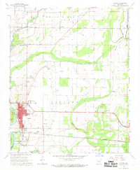
1968 Map of Augusta
USGS Topo · Published 1969About this map
The White River defines the western edge of this Arkansas landscape, where the Woodruff County seat of Augusta serves as a hub for the surrounding agricultural plains. The town's layout is centered around the Courthouse and Augusta High School, with the Missouri Pacific railroad line connecting the main settlement to New Augusta and onward toward Cavell. This survey captures the region's complex water network, dominated by oxbow features like Taylor Brake and Cypress Brake that mark the river's ancient path.
Find a feature on this map
42 named features on this map. Tap any name to fly to it.
Don’t see what you’re looking for? This feature index may not catch every label — zoom into the map to look around manually.
Map Details
Editions of this 1968 Augusta Map
2 editions found
Other maps of this area

1935 · Augusta
USGS Topo · 1:62,500

1935 · Gregory
USGS Topo · 1:62,500

1939 · Hunter
USGS Topo · 1:62,500

1940 · Tilton
USGS Topo · 1:62,500

1953 · Memphis
USGS Topo · 1:250,000

1956 · Memphis
USGS Topo · 1:250,000

1956 · Tilton
USGS Topo · 1:62,500

1956 · Hunter
USGS Topo · 1:62,500

1957 · Augusta
USGS Topo · 1:62,500

1957 · Gregory
USGS Topo · 1:62,500