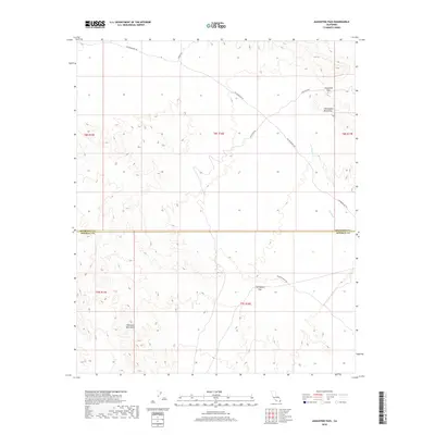
2018 Map of Augustine Pass
USGS Topo · Published 2018About this map
The Bradshaw Trl cuts across this arid landscape, following a historic gold-rush era corridor through the desert. This 2018 survey documents the remote borderlands where Riverside Co and Imperial Co meet, a region defined by the stark gap between the Chuckwalla Mountains to the north and the Chocolate Mountains to the south. The terrain is structured by critical mountain crossings, notably Augustine Pass and Surveyors Pass, which provide passage through these steep ranges. While modern vehicle access is indicated by Augustine Rd and Niland Rannels Rd, the hydrology remains dominated by ephemeral features like the Arroyo Seco, reflecting the harsh environment of the Colorado Desert. The map serves as a detailed record of high-desert topography, showing the network of trails and unimproved roads used by modern explorers tracing these historic routes.
Find a feature on this map
15 named features on this map. Tap any name to fly to it.
Don’t see what you’re looking for? This feature index may not catch every label — zoom into the map to look around manually.
Map Details
Editions of this 2018 Augustine Pass Map
This is the sole edition of this map. No revisions or reprints were ever made.
Other maps of this area

1940 · Iris Pass
USGS Topo · 1:62,500

1944 · Chuckwalla Mountains
USGS Topo · 1:62,500

1945 · Iris Pass
USGS Topo · 1:62,500

1952 · Sidewinder Well
USGS Topo · 1:62,500

1953 · Chuckwalla Spring
USGS Topo · 1:62,500

1954 · Salton Sea
USGS Topo · 1:250,000

1955 · Salton Sea
USGS Topo · 1:250,000
1956 · Iris Wash
USGS Topo · 1:24,000

1959 · Salton Sea
USGS Topo · 1:250,000

1963 · Salton Sea
USGS Topo · 1:250,000