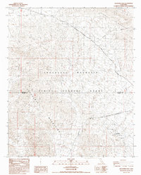
1987 Map of Augustine Pass
USGS Topo · Published 1987About this map
The Chocolate Mountain Aerial Gunnery Range dominates the southern landscape of this California desert region, marking a significant military footprint across the Chocolate Mountains. In the late 1980s, this area remained largely defined by its limited access and topographical barriers, with the Naval Reservation Boundary cutting through the arid terrain. Historical transit is represented by the Bradshaw Road in the north, a route of high importance for desert travel long before modern paving. Elevation changes are marked by distinct gateways through the peaks, including Augustine Pass in the Chuckwalla Mountains and Surveyors Pass further south. These natural corridors, along with the Augustine Road and the Niland Blythe Road, illustrate the sparse but essential transportation network connecting isolated points across the Arroyo Seco drainage system.
Find a feature on this map
11 named features on this map. Tap any name to fly to it.
Don’t see what you’re looking for? This feature index may not catch every label — zoom into the map to look around manually.
Map Details
Editions of this 1987 Augustine Pass Map
This is the sole edition of this map. No revisions or reprints were ever made.
Other maps of this area

1940 · Iris Pass
USGS Topo · 1:62,500

1944 · Chuckwalla Mountains
USGS Topo · 1:62,500

1945 · Iris Pass
USGS Topo · 1:62,500

1952 · Sidewinder Well
USGS Topo · 1:62,500

1953 · Chuckwalla Spring
USGS Topo · 1:62,500

1954 · Salton Sea
USGS Topo · 1:250,000

1955 · Salton Sea
USGS Topo · 1:250,000
1956 · Iris Wash
USGS Topo · 1:24,000

1959 · Salton Sea
USGS Topo · 1:250,000

1963 · Salton Sea
USGS Topo · 1:250,000