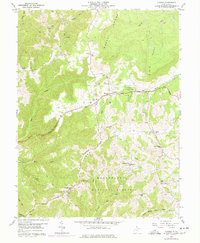
1959 Map of Aurora
USGS Topo · Published 1977About this map
Cathedral State Park stands as a preserved remnant of the ancient hemlock and beech forests that once covered these high ridges of Preston County. The George Washington Highway traverses the central terrain, connecting established upland settlements like Aurora and Brookside during the late 1950s. The map reveals a deeply rooted rural community, evidenced by the high density of small family and community landmarks such as Accident School, Accident Cemetery, and Stemple Ridge School.
Find a feature on this map
46 named features on this map. Tap any name to fly to it.
Don’t see what you’re looking for? This feature index may not catch every label — zoom into the map to look around manually.
Map Details
Editions of this 1959 Aurora Map
4 editions found
Other maps of this area

1886 · St. George
USGS Topo · 1:125,000

1891 · St. George
USGS Topo · 1:125,000

1895 · Piedmont
USGS Topo · 1:125,000

1899 · Oakland
USGS Topo · 1:62,500

1900 · Oakland
USGS Topo · 1:62,500

1907 · Kingwood
USGS Topo · 1:62,500

1908 · Parsons
USGS Topo · 1:62,500

1916 · Davis
USGS Topo · 1:48,000

1918 · Davis
USGS Topo · 1:62,500

1919 · Davis
USGS Topo · 1:62,500