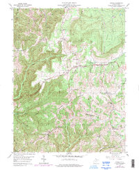
1959 Map of Aurora
USGS Topo · Published 1998About this map
The George Washington Highway traverses the high ridges of Preston County, connecting the small settlements of Aurora and Brookside during the late 1950s. This survey illustrates a rural Appalachian landscape where life centered on the high ground of Lantz Ridge and Stemple Ridge, rather than the deep creek valleys. The distribution of small country churches and schools, such as Stemple Ridge Ch and Accident Sch, reflects a dispersed but structured farming community.
Find a feature on this map
47 named features on this map. Tap any name to fly to it.
Don’t see what you’re looking for? This feature index may not catch every label — zoom into the map to look around manually.
Map Details
Editions of this 1959 Aurora Map
4 editions found
Other maps of this area

1886 · St. George
USGS Topo · 1:125,000

1891 · St. George
USGS Topo · 1:125,000

1895 · Piedmont
USGS Topo · 1:125,000

1899 · Oakland
USGS Topo · 1:62,500

1900 · Oakland
USGS Topo · 1:62,500

1907 · Kingwood
USGS Topo · 1:62,500

1908 · Parsons
USGS Topo · 1:62,500

1916 · Davis
USGS Topo · 1:48,000

1918 · Davis
USGS Topo · 1:62,500

1919 · Davis
USGS Topo · 1:62,500