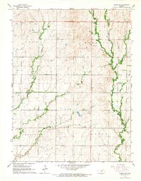
1965 Map of Aurora SW
USGS Topo · Published 1966About this map
The rolling hills of the Kansas plains define this mid-1960s landscape, where the rural townships of Lyon, Meredith, Sheridan, and Logan converge. A clear boundary line marks the division between Cloud and Ottawa counties, bisecting a region largely shaped by the meandering courses of Yockey Creek, West Pipe Creek, and Henry Creek. The map documents the scattered infrastructure of the era, from the local Bethel Ch and St Peters Ch to the Delphos Cem near the southwestern corner. Transportation and utility are visible in the placement of Roadside Parks and localized industrial activity like the Gravel Pit, providing a detailed look at the agricultural and social organization of North Central Kansas before extensive modern development.
Find a feature on this map
14 named features on this map. Tap any name to fly to it.
Don’t see what you’re looking for? This feature index may not catch every label — zoom into the map to look around manually.
Map Details
Editions of this 1965 Aurora SW Map
This is the sole edition of this map. No revisions or reprints were ever made.
Other maps of this area

1892 · Minneapolis
USGS Topo · 1:125,000

1952 · Glasco
USGS Topo · 1:24,000

1953 · Glasco NE
USGS Topo · 1:24,000

1955 · Manhattan
USGS Topo · 1:250,000

1956 · Manhattan
USGS Topo · 1:250,000

1957 · Manhattan
USGS Topo · 1:250,000

1961 · Tescott NE
USGS Topo · 1:24,000

1964 · Lamar
USGS Topo · 1:24,000

1965 · Aurora
USGS Topo · 1:24,000

1965 · Minneapolis North
USGS Topo · 1:24,000