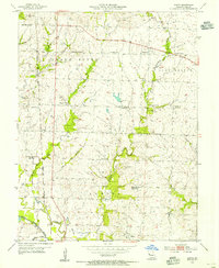
1954 Map of Austin
USGS Topo · Published 1955About this map
Austin and the winding Grand River anchor this mid-century survey of Cass County, Missouri. The landscape is defined by its rural school network, documenting a period of consolidation as several locations, including Houston Sch, Elm Branch Sch, and Mullin Sch, are noted as abandoned. The Missouri Pacific railroad runs through the western corridor, passing the small settlement of Lone Tree and the elevated terrain of Snowball Hill.
Find a feature on this map
31 named features on this map. Tap any name to fly to it.
Don’t see what you’re looking for? This feature index may not catch every label — zoom into the map to look around manually.
Map Details
Editions of this 1954 Austin Map
2 editions found
Other maps of this area

1887 · Harrisonville
USGS Topo · 1:125,000

1887 · Butler
USGS Topo · 1:125,000

1892 · Harrisonville
USGS Topo · 1:125,000

1894 · Harrisonville
USGS Topo · 1:125,000

1894 · Butler
USGS Topo · 1:125,000

1947 · Lawrence
USGS Topo · 1:250,000

1950 · Lawrence
USGS Topo · 1:250,000
1953 · Everett
USGS Topo · 1:24,000

1954 · Harrisonville
USGS Topo · 1:24,000
1954 · East Lynne
USGS Topo · 1:24,000