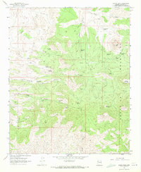
1968 Map of Austin Peak
USGS Topo · Published 1971About this map
Aquarius Mountains dominate this high-desert landscape in Mohave County, where the necessity of water in an arid environment is written across the terrain in a network of named springs and wells. In the late 1960s, these sources supported the ranching and transit through the high basins. Notable landmarks include the summit of Austin Peak and the nearby Snow Mountain, with a system of primitive routes like the Pack Trail and Jeep Trail connecting remote points. The naming of Schoolhouse Spring, Sheepcamp Spring, and Cow Creek Spring suggests a history tied to seasonal grazing and small-scale homesteading. Isolated water points such as Misery Well and Dripping Springs Well highlight the challenging nature of this territory, while larger drainages like Knight Creek and Dripping Springs Canyon provide the primary geographic structure for the region's topography.
Find a feature on this map
31 named features on this map. Tap any name to fly to it.
Don’t see what you’re looking for? This feature index may not catch every label — zoom into the map to look around manually.
Map Details
Editions of this 1968 Austin Peak Map
2 editions found
Other maps of this area

1886 · Diamond Creek
USGS Topo · 1:250,000

1892 · Diamond Creek
USGS Topo · 1:250,000

1923 · Signal
USGS Topo · 1:250,000

1942 · Signal
USGS Topo · 1:250,000

1948 · Williams
USGS Topo · 1:250,000

1950 · Prescott
USGS Topo · 1:250,000

1954 · Prescott
USGS Topo · 1:250,000

1954 · Williams
USGS Topo · 1:250,000

1956 · Williams
USGS Topo · 1:250,000

1958 · Prescott
USGS Topo · 1:250,000