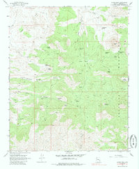
1968 Map of Austin Peak
USGS Topo · Published 1985About this map
The Aquarius Mountains define this high-elevation landscape in Mohave County, where the topography transitions between peaks like Austin Peak and Snow Mountain into significant depressions such as Cedar Basin and Knight Basin. The area is characterized by a high density of watering points, suggesting a reliance on dispersed water sources for local ranching or survival in the arid environment. These include developed points like Dripping Springs Well and Misery Well, alongside descriptively named features like Blue Mud Spring and Blackjack Spring. Evidence of early education or localized settlement is found at Schoolhouse Spring on the eastern slopes. A network of jeep trails provides the primary means of traversal through the complex drainage systems of Knight Creek and Divide Canyon, reflecting the land's remote and utilitarian character during the late 1960s.
Find a feature on this map
27 named features on this map. Tap any name to fly to it.
Don’t see what you’re looking for? This feature index may not catch every label — zoom into the map to look around manually.
Map Details
Editions of this 1968 Austin Peak Map
2 editions found
Other maps of this area

1886 · Diamond Creek
USGS Topo · 1:250,000

1892 · Diamond Creek
USGS Topo · 1:250,000

1923 · Signal
USGS Topo · 1:250,000

1942 · Signal
USGS Topo · 1:250,000

1948 · Williams
USGS Topo · 1:250,000

1950 · Prescott
USGS Topo · 1:250,000

1954 · Prescott
USGS Topo · 1:250,000

1954 · Williams
USGS Topo · 1:250,000

1956 · Williams
USGS Topo · 1:250,000

1958 · Prescott
USGS Topo · 1:250,000