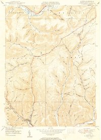
1950 Map of Austin
USGS Topo · Published 1950About this map
The Allegheny River and Freeman Run define the rugged valley settlement patterns of mid-century Potter County. In the south, the borough of Austin sits at the confluence of several steep hollows, showing a concentrated grid of streets and a Reservoir that supported the local population. Moving north along the winding Highway, the landscape transitions into a network of timbered ridges and family-named hollows like McNamara Hol and Chastain Hol.
Find a feature on this map
79 named features on this map. Tap any name to fly to it.
Don’t see what you’re looking for? This feature index may not catch every label — zoom into the map to look around manually.
Map Details
Editions of this 1950 Austin Map
2 editions found
Other maps of this area

1932 · Genesee
USGS Topo · 1:62,500

1934 · Coudersport
USGS Topo · 1:48,000

1937 · Genesee
USGS Topo · 1:62,500

1938 · Coudersport
USGS Topo · 1:62,500

1947 · Conrad
USGS Topo · 1:62,500

1947 · Conrad
USGS Topo · 1:24,000

1947 · Ayers Hill
USGS Topo · 1:24,000

1948 · Emporium
USGS Topo · 1:62,500

1948 · Keating Summit
USGS Topo · 1:24,000

1948 · Emporium
USGS Topo · 1:24,000