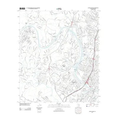
2013 Map of Austin West
USGS Topo · Published 2013About this map
Lake Austin and the Colorado River corridor anchor this 2013 topographical study of western Travis County. The terrain transitions from the suburban neighborhoods of West Lake Hills, Rollingwood, and Lost Creek to the natural elevations of Mount Bonnell and Mount Barker. Historical depth is found in the Camp Mabry Historic District and the Zilker Park Historic District, while numerous groundwater sources like Mormon Spring and Old Barton Springs dot the landscape. The infrastructure of the era is well-documented, featuring the Missouri Pacific railroad, the Lamar Boulevard Bridge, and established institutions such as Saint Stephens School and Camp Tom Wooten. Local history is preserved through named family plots including McNeil Cem and Preece Cem.
Find a feature on this map
61 named features on this map. Tap any name to fly to it.
Don’t see what you’re looking for? This feature index may not catch every label — zoom into the map to look around manually.
Map Details
Editions of this 2013 Austin West Map
This is the sole edition of this map. No revisions or reprints were ever made.
Other maps of this area

1896 · Austin
USGS Topo · 1:125,000

1897 · Austin
USGS Topo · 1:125,000

1910 · Austin
USGS Topo · 1:125,000

1930 · Austin-2
USGS Topo · 1:48,000

1932 · Mt. Bonnell
USGS Topo · 1:62,500

1954 · Austin East
USGS Topo · 1:24,000

1954 · Austin West
USGS Topo · 1:24,000

1954 · Austin
USGS Topo · 1:250,000

1955 · Montopolis
USGS Topo · 1:24,000

1955 · Oak Hill
USGS Topo · 1:24,000