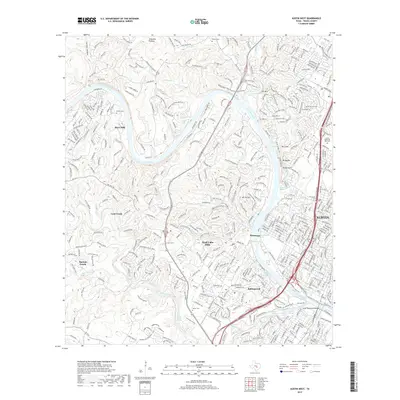
2019 Map of Austin West
USGS Topo · Published 2019About this map
The Colorado River and its dramatic limestone bluffs anchor this map of western Austin and its affluent suburban hill country. The landscape is defined by the winding waters of Lake Austin and Lady Bird Lake, where the Lamar Boulevard Bridge connects the urban core to the natural springs and recreation areas south of the river. High points like Mt Bonnell and Mt Barker rise above the river valley, while the Jollyville Plateau dominates the northern reaches. This 2019 survey documents the modern footprint of communities like West Lake Hills, Rollingwood, and Lost Creek, showing a dense network of residential streets carved into the canyon topography. Local history is marked by several burial grounds, including the Austin Memorial Park Cem and the older McNeil Cem, alongside well-known hydrological features like Barton Springs and the Mount Bonnell Spring.
Find a feature on this map
56 named features on this map. Tap any name to fly to it.
Don’t see what you’re looking for? This feature index may not catch every label — zoom into the map to look around manually.
Map Details
Editions of this 2019 Austin West Map
This is the sole edition of this map. No revisions or reprints were ever made.
Other maps of this area

1896 · Austin
USGS Topo · 1:125,000

1897 · Austin
USGS Topo · 1:125,000

1910 · Austin
USGS Topo · 1:125,000

1930 · Austin-2
USGS Topo · 1:48,000

1932 · Mt. Bonnell
USGS Topo · 1:62,500

1954 · Austin East
USGS Topo · 1:24,000

1954 · Austin West
USGS Topo · 1:24,000

1954 · Austin
USGS Topo · 1:250,000

1955 · Montopolis
USGS Topo · 1:24,000

1955 · Oak Hill
USGS Topo · 1:24,000