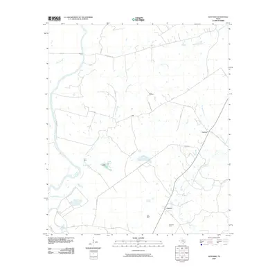
2010 Map of Austonio
USGS Topo · Published 2010About this map
Alabama Ferry and the broad curves of the Trinity River anchor the western edge of this Houston County landscape, where rural life is defined by a network of creeks and small settlements. The community of Austonio serves as a local hub near the intersection of FM 1280 and Blackhouse Creek, while the smaller hamlet of Ash sits more centrally, positioned near Bogg Cemetery. To the south, the village of Mapleton marks the junction of FM 3275, surrounded by large landholdings like the Seven J Ramp Ranch and Rattlesnake Ranch. The map reveals a managed water system in the central-west, featuring Coon Lake 1 and Coon Lake 2 held by Coon Dam 1 and Coon Dam 2. Tributaries like Henderson Creek, Big Creek, and Georgia Camp Creek drain the undulating terrain, following a drainage pattern that has shaped the placement of farm-to-market roads and cattle operations for generations.
Find a feature on this map
34 named features on this map. Tap any name to fly to it.
Don’t see what you’re looking for? This feature index may not catch every label — zoom into the map to look around manually.
Map Details
Editions of this 2010 Austonio Map
This is the sole edition of this map. No revisions or reprints were ever made.
Other maps of this area

1953 · Palestine
USGS Topo · 1:250,000

1957 · Palestine
USGS Topo · 1:250,000

1964 · Sand Ridge
USGS Topo · 1:24,000

1964 · Austonio
USGS Topo · 1:24,000

1964 · Porter Springs
USGS Topo · 1:24,000

1964 · Pearsons Chapel
USGS Topo · 1:24,000

1964 · Eunice
USGS Topo · 1:24,000

1964 · Middleton
USGS Topo · 1:24,000
1964 · Weldon
USGS Topo · 1:24,000

1964 · Halls Bluff
USGS Topo · 1:24,000