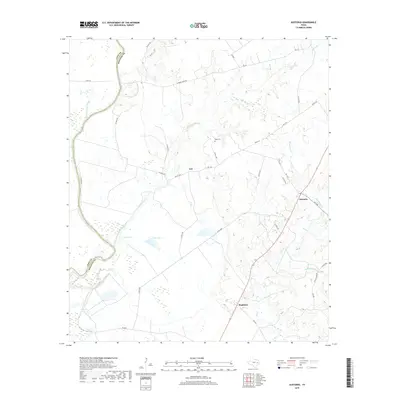
2019 Map of Austonio
USGS Topo · Published 2019About this map
The Trinity River defines the western edge of this Houston County landscape, where the river's winding course creates a complex network of wetlands and seasonal water bodies like Pecan Slough. Inland, the settlement of Austonio serves as a local crossroads at the intersection of FM 1280 and several county routes. The terrain is defined by its drainage towards the Trinity, with Henderson Cr and Big Cr carving through the countryside near the small communities of Mapleton and Ash. Local history is anchored by sites such as Bogg Cem, while the hydrological character of the region is further shaped by Coon Lake 1 and Coon Lake 2. This map reflects the enduring rural character of East Texas, where the economy remains tied to the land and the proximity of the river, as seen in the name Alabama Ferry Rd.
Find a feature on this map
40 named features on this map. Tap any name to fly to it.
Don’t see what you’re looking for? This feature index may not catch every label — zoom into the map to look around manually.
Map Details
Editions of this 2019 Austonio Map
This is the sole edition of this map. No revisions or reprints were ever made.
Other maps of this area

1953 · Palestine
USGS Topo · 1:250,000

1957 · Palestine
USGS Topo · 1:250,000

1964 · Sand Ridge
USGS Topo · 1:24,000

1964 · Austonio
USGS Topo · 1:24,000

1964 · Porter Springs
USGS Topo · 1:24,000

1964 · Pearsons Chapel
USGS Topo · 1:24,000

1964 · Eunice
USGS Topo · 1:24,000

1964 · Middleton
USGS Topo · 1:24,000
1964 · Weldon
USGS Topo · 1:24,000

1964 · Halls Bluff
USGS Topo · 1:24,000