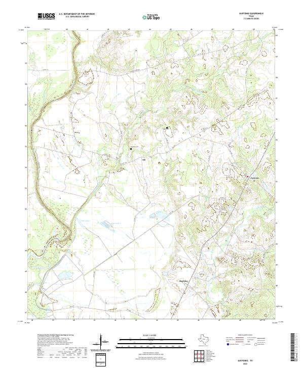
2022 Map of Austonio
USGS Topo · Published 2022About this map
The Trinity River defines the southwestern boundary of this landscape, carving a wide alluvial plain across the Houston Co and Leon Co line. Central to the region is the small settlement of Ash, surrounded by family burial grounds like Murphys Cem and Bogg Cem. The rural road network, including the evocative Alabama Ferry Rd, suggests a long history of river-crossing commerce and regional transit. Toward the east, the community of Austonio sits at a junction near Blackhouse Cr, while Mapleton anchors the southern portion of the sheet. Between these points, the land is characterized by drainage systems like Henderson Cr and the distinct shoreline of Coon Lake 1 and Coon Lake 2, reflecting the hydrological complexity of the East Texas bottomlands.
Find a feature on this map
41 named features on this map. Tap any name to fly to it.
Don’t see what you’re looking for? This feature index may not catch every label — zoom into the map to look around manually.
Map Details
Editions of this 2022 Austonio Map
This is the sole edition of this map. No revisions or reprints were ever made.
Other maps of this area

1953 · Palestine
USGS Topo · 1:250,000

1957 · Palestine
USGS Topo · 1:250,000

1964 · Sand Ridge
USGS Topo · 1:24,000

1964 · Austonio
USGS Topo · 1:24,000

1964 · Porter Springs
USGS Topo · 1:24,000

1964 · Pearsons Chapel
USGS Topo · 1:24,000

1964 · Eunice
USGS Topo · 1:24,000

1964 · Middleton
USGS Topo · 1:24,000
1964 · Weldon
USGS Topo · 1:24,000

1964 · Halls Bluff
USGS Topo · 1:24,000