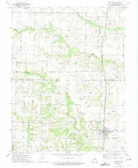
1972 Map of Auxvasse
USGS Topo · Published 1974About this map
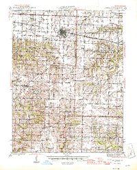
Auxvasse serves as the primary hub of this north-central Callaway County landscape in the early 1970s, situated where the Gulf Central Illinois railroad cuts through the prairie. The map documents a transition from the level agricultural uplands of Jackson and Liberty townships to the deeply incised drainage networks of the Salt River. To the west, the small settlement of Concord remains a notable landmark, while the northern reaches of the sheet near Ortiz show the rolling terrain surrounding the Scattering Fork. Local genealogy is well-preserved through several landmarks, including the Grand Prairie Cem and Auxvasse Cem, alongside rural houses of worship such as Bethel Ch. The intricate path of Beaverdam Creek and its various tributaries like Bynum Creek and Smith Branch illustrates the complex water system that has historically shaped the county's boundaries and farm placements.
Find a feature on this map
19 named features on this map. Tap any name to fly to it.
Don’t see what you’re looking for? This feature index may not catch every label — zoom into the map to look around manually.
Map Details
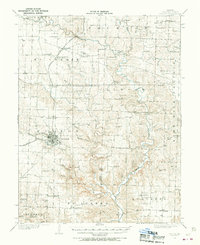
Editions of this 1972 Auxvasse Map
This is the sole edition of this map. No revisions or reprints were ever made.
Other maps of this area

1886 · Jefferson City
USGS Topo · 1:125,000

1890 · Mexico
USGS Topo · 1:125,000

1890 · Moberly
USGS Topo · 1:125,000

1890 · Fulton
USGS Topo · 1:125,000

1894 · Jefferson City
USGS Topo · 1:125,000
1928 · Fulton
USGS Topo · 1:62,500
1931 · Fulton
USGS Topo · 1:62,500
1932 · Mexico
USGS Topo · 1:62,500

1944 · Millersburg
USGS Topo · 1:62,500
1945 · Centralia
USGS Topo · 1:62,500