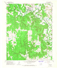
1966 Map of Avant
USGS Topo · Published 1967About this map
The town of Avant serves as the focal point of this mid-1960s survey within the Osage Indian Reservation. Located near the intersection of Bird Creek and Candy Creek, the settlement is supported by the Midland Valley railroad line, which follows the winding river valley. The map reveals a landscape defined by significant topographic relief and industrial activity, including several quarries and the Black Dog Field in the southern portion of the quadrangle. Genealogists and local historians can locate the Avant Cem and Lombard Cem, while the smaller settlements of Midland, Dripping Spring, and Javine highlight the rural development of Osage County. The convergence of numerous watercourses, such as Tucker Creek and Tyner Creek, into the Big Heart Valley illustrates the complex drainage patterns that shaped early transportation and land use in this part of Oklahoma.
Find a feature on this map
24 named features on this map. Tap any name to fly to it.
Don’t see what you’re looking for? This feature index may not catch every label — zoom into the map to look around manually.
Map Details
Editions of this 1966 Avant Map
4 editions found
Other maps of this area

1901 · Claremore
USGS Topo · 1:125,000

1901 · Nowata
USGS Topo · 1:125,000

1909 · Pawhuska
USGS Topo · 1:125,000

1910 · Pawhuska
USGS Topo · 1:125,000

1912 · Hominy
USGS Topo · 1:125,000

1914 · Nowata
USGS Topo · 1:125,000

1914 · Claremore
USGS Topo · 1:125,000

1915 · Hominy
USGS Topo · 1:125,000

1916 · Claremore
USGS Topo · 1:125,000

1954 · Tulsa
USGS Topo · 1:250,000