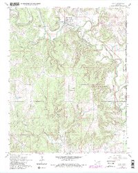
1966 Map of Avant
USGS Topo · Published 1983About this map
Avant sits at the northern edge of this survey, established where the Missouri Pacific railroad meets the meandering path of Bird Creek. The landscape is defined by its industrial and tribal heritage, situated within the Indian Reservation Boundary and marked by the expansive oil and gas operations of Big Heart Field, Black Dog Field, and Skiatook Field. These energy-producing tracts dominate the southern half of the map, interspersed with local drainages like Javine Creek and East Prong Quapaw Creek. Genealogists will find the Avant Cem and Lombard Cem clearly plotted, while the presence of a Gaging Sta and multiple Quarries reflects the managed utility of the river valley. The terrain transitions from the developed town site to the more secluded landmark at Dripping Spring, illustrating the rural character of Osage County in the mid-1960s.
Find a feature on this map
25 named features on this map. Tap any name to fly to it.
Don’t see what you’re looking for? This feature index may not catch every label — zoom into the map to look around manually.
Map Details
Editions of this 1966 Avant Map
4 editions found
Other maps of this area

1901 · Claremore
USGS Topo · 1:125,000

1901 · Nowata
USGS Topo · 1:125,000

1909 · Pawhuska
USGS Topo · 1:125,000

1910 · Pawhuska
USGS Topo · 1:125,000

1912 · Hominy
USGS Topo · 1:125,000

1914 · Nowata
USGS Topo · 1:125,000

1914 · Claremore
USGS Topo · 1:125,000

1915 · Hominy
USGS Topo · 1:125,000

1916 · Claremore
USGS Topo · 1:125,000

1954 · Tulsa
USGS Topo · 1:250,000