
1915 Map of Hominy
USGS Topo · Published 1915About this map
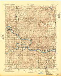
The confluence of the Cimarron River and the Arkansas River defines the landscape of this pre-WWI Oklahoma survey, where river transport and early rail networks intersect. Significant for its depiction of tribal history, the map identifies Black Dog (Indian Village) near Hominy Creek. The region is in the midst of an early twentieth-century energy boom, evidenced by settlements like Oil City and the presence of the St Louis and San Francisco RR and the Midland Valley RR.
Find a feature on this map
76 named features on this map. Tap any name to fly to it.
Don’t see what you’re looking for? This feature index may not catch every label — zoom into the map to look around manually.
Map Details
Editions of this 1915 Hominy Map
2 editions found
Other maps of this area

1896 · Okmulgee
USGS Topo · 1:125,000

1900 · Okmulgee
USGS Topo · 1:125,000

1901 · Claremore
USGS Topo · 1:125,000

1901 · Nowata
USGS Topo · 1:125,000

1901 · Nuyaka
USGS Topo · 1:125,000

1909 · Pawhuska
USGS Topo · 1:125,000

1910 · Pawhuska
USGS Topo · 1:125,000

1912 · Hominy
USGS Topo · 1:125,000

1914 · Kiefer
USGS Topo · 1:62,500

1914 · Nowata
USGS Topo · 1:125,000